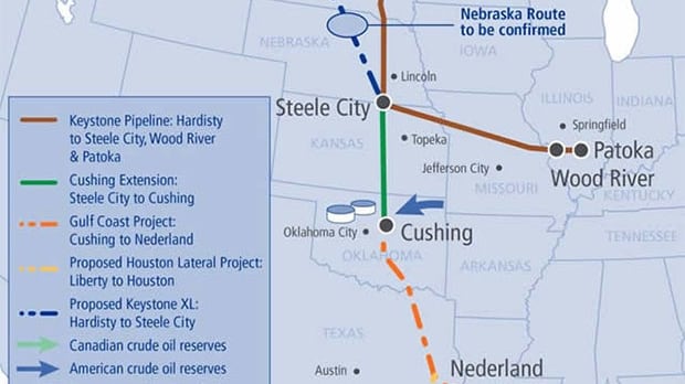
Proposed Keystone XL: Hardisty to Steele City
The Keystone XL is a proposed pipeline extending nearly 2,000 kilometres from Hardisty, Alberta to Steele City, Nebraska. Its proposed route travels through Montana, South Dakota and Nebraska, with connections to existing refineries along the Gulf Coast in Texas. The $7-billion pipeline would carry 700,000 barrels of bitumen each day. It is estimated it would create approximately 9,000 jobs during the construction period.
KEY DATES:
2010: Canada’s National Energy Board gives regulatory approval to the Keystone XL pipeline.
Jan. 2012: U.S. President Barack Obama temporarily blocks the Keystone pipeline, citing environmental concerns with its proposed route.
Sept. 2012: Pipeline builder TransCanada Corp. submits alternate pipeline route around Nebraska’s Sandhills, the portion of the line that concerned Obama.
May 2012: TransCanada submits another application for a Presidential Permit to U.S. Department of State, a requirement for construction a cross border pipeline.
Nov. 2012: Roughly 3,000 environmentalists rally outside White House to voice opposition to the pipeline.
Jan. 2013: Nebraska Governor Dave Heineman gives nod to proposed new route.
Feb. 2013: Enviromentalists hold a follow-up rally in Washington, D.C. urging Obama to reject the pipeline.
Jan. 2014: U.S. State Department releases a report stating the pipeline project will not significantly impact greenhouse emissions.
TBA: Decision date of the Presidential Permit.