

Tracking Hurricane Milton: Storm becomes world's strongest of 2024
EDITOR'S NOTE: This is CTV News' Tuesday edition of the Hurricane Milton live tracker. Click here to read live updates through Wednesday.
U.S. forecasters are warning of destructive waves, devastating winds and flash flooding through the week as Hurricane Milton makes its way from the Yucatan Peninsula towards Florida.
Milton is expected to grow in size and reach the west coast of Florida on Wednesday as a Category 3 storm, with wind speeds between 180-210 km/h.
“This is an extremely life-threatening situation,” reads the U.S. National Hurricane Center’s Tuesday morning advisory.
Follow along for live updates throughout the day.
7:45 p.m. EDT: In the eye of the storm
Nick Underwood from the National Oceanic and Atmospheric Administration filmed himself and other crew members aboard the WP-3D Orion to collect data on Hurricane Milton.
This aircraft is part of a Lockheed “Hurricane Hunters” fleet that collects data on tropical cyclone research and forecasting. The two aircrafts nicknamed "Kermit" (N42RF) and "Miss Piggy" (N43RF) have supported research in the Atlantic, Caribbean, Gulf of Mexico and the Eastern Pacific.
6:20 p.m. EDT: Strongest storm of 2024
After reaching peak intensity with wind speeds of 180 m.p.h. (285 km/h) on Monday night, Milton became the strongest storm on our planet for 2024.
In late June, Hurricane Beryl, a Category 5 storm, was at the top of the list reaching peak wind speeds of 168 m.p.h. (270 km/h). The cyclone impacted parts of the Caribbean, the Yucatan Peninsula and the U.S. Gulf Coast, with remnants reaching as far as Ontario. The storm caused 70 fatalities and US$6.86 billion in damages.
Last month, Typhoon Krathon, or Super Typhoon Julian, reached a maximum wind speed of 120 m.p.h. (195 km/h). It impacted Taiwan and the Philippines and caused more than 18 fatalities, as well as around US$38.8 million in damages.
Typhoon Yagi in Southeast Asia and southeast China also reached peak speeds of 120 m.p.h. (195 km/h) in early September. A total of 830 fatalities were recorded, along with up to US$16.5 billion in damages.
5:50 p.m. EDT: The hunt for gasoline is adding to Floridians' anxiety
Florida gas stations struggled to keep up with demand Tuesday as long lines and empty pumps compounded the stress for residents planning to hunker down or flee as Hurricane Milton approached the state's western coast.
U.S. Gov. Ron DeSantis said during a morning news conference that state officials, including the Florida Highway Patrol, were working with fuel companies to continue bringing in gasoline ahead of Milton's expected landfall on Wednesday. Troopers escorted 27 fuel trucks to stations Monday night, DeSantis said.
DeSantis outlined replenishment efforts during his morning news conference and stressed that there wasn't a fuel shortage.
Haven Daley And Kevin Mcgill from The Associated Press
5:30 p.m. EDT: Health department warns of flesh-eating bacteria
The Florida Department of Health is warning residents to avoid floodwaters to prevent exposure to flesh-eating bacteria.
"Vibrio bacteria, commonly found in warm coastal waters, can cause illness when ingested or when open wounds are exposed to contaminated water," the announcement says.
"After heavy rainfall and flooding, the concentration of these bacteria may rise, particularly in brackish and saltwater environments."
Symptoms may include diarrhea, vomiting, abdominal pain, fever, chills, fast or high heart rate, confusion or disorientation.
To protect residents from contracting the bacteria, the health agency is urging people to avoid swimming or wading in floodwaters, standing water, seawater and brackish water, if possible.
Additionally, open cuts or wounds should be covered with waterproof bandages.
 Tyler Griffin secures his boat in preparation for Hurricane Milton on Tuesday, Oct. 8, 2024, in New Port Richey, Fla. (Mike Carlson / AP Photo)
5 p.m. EDT: Hurricane Milton restrengthens to a Category 5 storm
The U.S. National Hurricane Center designated Hurricane Milton as a Category 5 storm again after reaching wind speeds of 165 m.p.h. (270 km/h).
The location of the storm is currently about 480 miles (775 kilometres) southwest of Tampa.
"Florida residents should get their families and homes ready and evacuate if told to do so," the agency’s advisory added.
4:45 p.m. EDT: Hurricane Milton nears a Category 5 storm again
Hurricane Milton is nearing a Category 5 storm again after picking up speed on Tuesday afternoon.
Wind speeds increased to 155 m.p.h. (250 km/h), according to the U.S. National Hurricane Center. A storm becomes a Category 5 once it reaches 157 m.p.h. (253 km/h.)
4:30 p.m. EDT: Anna Maria Island residents fatigued from Helene
“I’m still in shock over the first one and here comes round two,” said Evan Purcell of Anna Maria Island, who stayed for Helene but is evacuating for Milton.
“I just have a pit in my stomach about this one.”
He packed up his father’s ashes and was trying to catch his 9-year-old cat, McKenzie, as he prepared to leave. Helene left him with thousands of dollars in damage when his home flooded. He’s now worried Milton may take whatever is left. “It’s a coin toss,” he said.
4 p.m. EDT: Walt Disney World announces temporary closure
Beginning on Wednesday, Disney theme parks and Disney Springs will be closed in phases, according to a press release.
Disney's Hollywood Studios and Disney's Animal Kingdom theme park will close at 1 p.m. Magic Kingdom park, EPCOT and Disney Springs will close at 2 p.m.
The parks will likely remain closed until Thursday. Event tickets will be refunded to customers.
The resort's hotels will also temporarily close on Wednesday and will likely remain closed until Sunday.
This will be just the 12th time in the park's 53-year history that it will temporarily close, according to the fan-published Walt Disney World Magazine. Of the 11 previous closures, nine were due to hurricanes, most recently Ian in September 2022 and Nicole in November 2022. The park also closed following the Sept. 11 terrorist attacks in 2001 and during the COVID-19 pandemic.
 Guests at the Magic Kingdom break out ponchos at Cinderella Castle as bands of weather from Hurricane Helene move through Walt Disney World in Bay Lake, Fla., Thursday, Sept. 26, 2024. (Joe Burbank / Orlando Sentinel via AP)
3:35 p.m. EDT: What causes hurricanes?
Hurricanes often start as tropical waves that combine with warm ocean waters, according to the National Oceanic and Atmospheric Administration. They may also be fueled by thunderstorms. The weather system moves west as warm ocean air rises into it, and that creates a low pressure area underneath it, NOAA said. Air rises and cools, and that forms clouds and thunderstorms.
Hurricanes have maximum sustained winds — the highest one-minute average wind speed at a particular point in time — of 74 m.p.h. (120 km/h) or higher. If a tropical cyclone has maximum sustained winds between 39 and 73 m.p.h. (63 km/h to 120 km/h), it’s called a tropical storm. If maximum sustained winds are less than 39 m.p.h. (63 km/h), it’s called a tropical depression.
Hurricanes typically occur during hurricane season, which in the Atlantic basin occurs each year from June 1 to Nov. 30.
Patrick Whittle from the Associated Press
 A person takes photos at the harbor amid rain as Hurricane Milton passes near Progreso, Yucatan state, Mexico, Tuesday, Oct. 8, 2024. (Martin Zetina / AP Photo)
3:30 p.m. EDT: Universal Orlando Resort, SeaWorld announce closure
Universal Resort is making operational changes ahead of Hurricane Milton's arrival.
On Wednesday, Universal Studios Florida, Islands of Adventure and Universal CityWalk will remain open until 2 p.m. local time and stay closed on Thursday. Universal Volcano Bay will be closed on both days with Halloween Horror Nights cancelled for Wednesday and Thursday. The hotels will remain operational.
The resort is anticipating a full reopening on Friday pending the outcome of the storm.
Similarly, SeaWorld Orlando issued a statement saying the park will be closed on Wednesday and Thursday in hopes of reopening on Friday.
3:00 p.m. EDT: Small evacuation plane crashes in Tampa
A plane carrying four passengers crashed into Tampa Bay on Tuesday when the engine failed after taking off from Albert Whitted Airport in St. Petersburg, a spokesperson for the St. Petersburg Fire Rescue confirmed.
Ashlie Handy said the passengers, all men between 25 and 40, were attempting to flee Hurricane Milton.
Three of the passengers were taken to Orlando Health Bayfront Hospital with non-life-threatening injuries.
The plane sank near the St. Petersburg Pier after crashing into the bay where the passengers were rescued 500 feet from shore, where they were met by a fire rescue crew and local police.
So far, 11 Florida counties are under mandatory evacuation orders that affect nearly 5.9 million people, according to county-level population estimates from the U.S. Census Bureau.
2:30 p.m. EDT: 'You are going to die': Tampa mayor advises against riding hurricane out
In a CNN interview on Monday, Tampa Mayor Jane Castor discussed the risk residents face ahead of Hurricane Milton.
“Right now, the possibility of a direct hit with 10 to 12-foot tidal surge — put that in perspective, Hurricane Helene, which just left the Tampa Bay area a week ago, there was 6-foot storm surge and that was literally devastating to so many in our coastal areas,” Castor said.
In response to a question about residents who’ve chosen to stay during previous hurricanes and may ride out Hurricane Milton, Castor advised against it.
“Helene was a wake-up call, this is literally catastrophic and I can say without any dramatization whatsoever: If you choose to stay in one of those evacuation areas, you are going to die,” she said.
 Tampa Mayor Jane Castor speaks on the risks associated with Hurricane Milton during an interview on Monday, Oct. 7, 2024.
2:25 p.m. EDT: Biden issues warning
Hurricane Milton "could be one of the worst storms in 100 years to hit Florida," U.S. President Joe Biden told reporters in Washington, D.C., on Tuesday after being briefed by administration officials.
"It's a matter of life and death. And that's not hyperbole. It's a matter of life and death," he said, calling on locals to evacuate affected areas immediately.
He says he has cancelled his trips to Europe and Africa in order to stay in the country as the storm approaches.
 U.S. President Joe Biden delivers remarks on the federal government's preparations for Hurricane Milton in the Roosevelt Room of the White House in Washington, Tuesday, Oct. 8, 2024. (Evan Vucci / AP Photo)
2:00 p.m. EDT: Construction crane warnings
St. Petersburg’s mayor, Ken Walch, warned residents of the dangers related to construction cranes in the city.
“Due to tower crane height and design, there are four construction sites in the downtown St. Petersburg area… that are susceptible to the anticipated high winds forecast for the approaching hurricane,” Walch said in a Tuesday briefing.
“This means residents near those four construction sites are at risk for those cranes malfunctioning during the storm.”
Since planning for the lowering of cranes takes weeks of preparation, the time frame of the hurricane did not allow operators to make prior adjustments, he added.
The mayor is advising residents to relocate or move to an inner room without windows as the storm passes.
1:45 p.m. EDT: Floridians go to hardware stores
“I just needed to grab some more ratchet straps to tie some of the patio furniture down to the house,” Florida resident Lenny Cabanero-Harvey told Reuters.
She’s one of many Floridians making trips to the hardware store in an effort to storm-proof their homes and businesses.
“Yesterday, I came here and there was stacks and stacks of plywood, and all of the workers here were just in good spirits trying to just keep everybody really calm,” she said, while standing in a Home Hardware parking lot in Valrico, a satellite community to Tampa.
Shane Slonaker and his brother, Dakota, piled their red pickup truck with sheets of wood.
"It's kind of scary,” he told Reuters. “A lot of high winds when you don't really experience normally. Just got to keep going on, you know?"
Residents there have fresh memories of Hurricane Helene, which missed Tampa but caused widespread destruction and loss of life elsewhere in the country when it made landfall two weeks ago. At least 230 people have been reported dead.
While Milton is forecast to slow to a Category 3 hurricane by the time it makes landfall in Florida, it’s expected to be one of the region’s most devastating storms in the last century.
 Employees at The Goodz hardware store, remove all the merchandise in advance of Hurricane Milton, Monday, Oct. 7, 2024, in Fort Myers Beach, Fla. (AP Photo/Marta Lavandier)
1:30 p.m. EDT: Bahamas under storm watch
According to an advisory from the U.S. National Hurricane Center, the government of the Bahamas issued a Tropical Storm Watch in northwestern Bahamas, including Grand Bahama Island, the Abacos and Bimini.
“Residents should prepare for tropical storm conditions, including strong winds and heavy rain, as Milton is expected to pass near the Bahamas from late Wednesday,” Latrae L. Rahming, an official spokesperson for the government of The Bahamas, wrote on X.
 Parts of the Bahamas are under a Tropical Storm Watch. (AccuWeather)
12:45 p.m. EDT: Time-lapse from space
Matthew Dominick, an astronaut aboard SpaceX’s Dragon Endeavour, recorded a time-lapse video from the spacecraft’s window while flying over Hurricane Milton.
"That's frightening," replied one X user. “We're locked into our beloved bubble at the mercy of the wills of nature.”
11:50 a.m. EDT: Canada weather unaffected
Milton won't affect weather in Canada, according to the Canadian Hurricane Centre, which released its own modelling Tuesday morning.
The same goes for Hurricane Leslie, which is churning in the Atlantic. That storm is expected to travel northwest until Thursday morning, when it’s forecast to make a sharp right turn and continue northeast until Sunday.
![]() This map shows the forecast paths of hurricanes Milton and Leslie (Source: ECCC)
This map shows the forecast paths of hurricanes Milton and Leslie (Source: ECCC)
11:15 a.m. EDT: Milton forecast changes
Milton is now expected to make landfall on the west coast of Florida on Wednesday night, U.S. national forecasters say, rather than Wednesday morning. Despite this, authorities say there likely won’t be enough time to evacuate on Wednesday.
While the storm is expected to drift ashore midway up the coast, it’s too soon to say exactly where it will land. Once it reaches the west coast of Florida, the storm is likely to cross over the peninsula and enter Atlantic waters on Thursday.
Milton’s high winds are forecast to expand as it approaches land, and nearly double in size by the time it makes landfall.
“Damaging winds, life-threatening storm surge, and heavy rainfall will extend well outside the forecast cone,” reads the U.S. National Hurricane Center’s 11 a.m. EDT update.
“Evacuations and other preparations should be completed today. Milton has the potential to be one of the most destructive hurricanes on record for west-central Florida.”
9:35 a.m. EDT: Canada issues travel advisory
Travellers should avoid non-essential travel to Florida’s coasts, the Canadian government has warned.
Hurricane Milton could disrupt transportation systems, electricity availability, water and food supply, telecommunications, emergency services and medical care, according to the travel advisory.
The advisory extends from the west coast -- from Chokoloskee to the mouth of the Suwanee River, including Tampa Bay – to the area between St. Lucie/Indian River County Line northward to Ponte Vedra Beach, on the east coast.
If you are near the affected areas, be cautious, monitor local news and weather reports, and follow instructions from authorities, reads the advisory.
![]() This map, produced by Florida's emergency management division, shows areas expected to be affected by storm surges.
This map, produced by Florida's emergency management division, shows areas expected to be affected by storm surges.
8:30 a.m. EDT: 'Time is running out'
In a news conference Tuesday morning, Florida Gov. Ron DeSantis urged people to leave their homes as soon as they can if they are in a disaster zone.
Traffic is expected to be heavy toward relief areas on Tuesday, because “there are only so many places you can go,” he said. He reiterated there are shelter areas available tens of miles away, and that residents don’t need to drive for hours to evade the storm.
Traffic ramped up by 150 per cent above normal on the interstate Monday evening, and similar congestion is expected on Tuesday. At its peak last night, traffic on Interstate 25 averaged around 20 m.p.h. (40 km/h), according to the governor.
 A view of a stretch of the I-75 where northbound traffic is slowed due to residents trying to evacuate flood zones. (Sources: Google Maps, FL511.com)
Power outages are expected when Milton makes landfall. Residents in affected areas should ensure their devices are charged. Uber is also offering free rides to and from shelters in affected areas with the promocode “MiltonRelief.”
DeSantis said the Helene disaster relief fund, which accepts private donations from individuals and corporations, has raised US$4 million. The fund will remain open to help pay for damage caused by Milton.
“We can rebuild homes, we can rebuild businesses,” he said. “You do have time to get to a shelter, but that time is running out.”
7:35 a.m. EDT: Airlines affected
Tampa International Airport will suspend flights at 9 a.m. EDT Tuesday, staff wrote on social media.
"TPA is not a shelter for people or vehicles," reads the post. Parking lots will be closed.
Peter O. Knight, Tampa Executive and Plant City airports, all of which are operated by the Hillsborough County authority, will close around the same time.
Orlando International Airport will close at 8 a.m. EDT on Wednesday.
Those closures are expected to affect scheduled flights to and from Canadian airports.
Toronto Pearson said it's monitoring the situation closely.
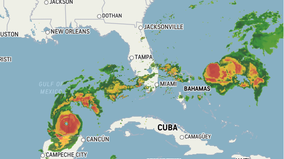
7 a.m. EDT: Satellite captures churning storm
Colorado State University's Cooperative Institute for Research in the Atmosphere has released overnight satellite imagery of Milton moving east.
6:35 a.m. EDT: Evacuations underway
Traffic data from Google Maps shows some congestion northbound on Interstate 75 north of Tampa. We saw images of heavy traffic on the highway late Monday as people moved out of flood zones.
Florida Gov. Ron DeSantis said earlier that the state has suspended tolls and opened roadway shoulders to allow for increased volumes.
"You do not need to travel hundreds of miles from home to evacuate safely—every county has pet-friendly shelters, special needs shelters, and other options that are safe from storm surge," he said in a social media post.
Thirty-thousand hydro workers are being relocated from elsewhere in the U.S. to restore power in the storm's wake, he added.
 Heavy traffic flows northbound on Interstate-75 as people evacuate the Tampa Bay area ahead of Hurricane Milton's arrival late Monday, Oct. 7, 2024, in Ocala, Fla. (AP Photo/Julio Cortez)
6 a.m. EDT: Florida still cleaning up Helene
Milton is expected to make landfall in Florida in the Tampa Bay area, which is home to more than 3 million people.
The state's emergency management department has ordered evacuations across the west coast.
Many are still cleaning up from Helene, the deadliest hurricane to hit the mainland U.S. since Katrina in 2005. At least 230 people have been reported dead. On Florida's Gulf Coast, it destroyed homes, tore down trees and flooded communities.
5:15 a.m. EDT: Hurricane Milton path map
Federal forecasters say “damaging hurricane-force winds and a life-threatening storm surge” are expected across the northern coast of the Yucatan Peninsula on Tuesday.
In its 4 a.m. CDT (5 a.m. EDT) advisory, the National Hurricane Center located the eye of the storm northeast of Progreso, Mexico.
![]() (Source: NOAA)
(Source: NOAA)
With files from The Associated Press
Shopping Trends
The Shopping Trends team is independent of the journalists at CTV News. We may earn a commission when you use our links to shop. Read about us.


CTVNews.ca Top Stories

opinion
opinion Tom Mulcair: Prime Minister Justin Trudeau's train wreck of a final act
In his latest column for CTVNews.ca, former NDP leader and political analyst Tom Mulcair puts a spotlight on the 'spectacular failure' of Prime Minister Justin Trudeau's final act on the political stage.
B.C. mayor gets calls from across Canada about 'crazy' plan to recruit doctors
A British Columbia community's "out-of-the-box" plan to ease its family doctor shortage by hiring physicians as city employees is sparking interest from across Canada, says Colwood Mayor Doug Kobayashi.
'There’s no support': Domestic abuse survivor shares difficulties leaving her relationship
An Edmonton woman who tried to flee an abusive relationship ended up back where she started in part due to a lack of shelter space.
opinion
opinion King Charles' Christmas: Who's in and who's out this year?
Christmas 2024 is set to be a Christmas like no other for the Royal Family, says royal commentator Afua Hagan. King Charles III has initiated the most important and significant transformation of royal Christmas celebrations in decades.
Baseball Hall of Famer Rickey Henderson dead at 65, reports say
Rickey Henderson, a Baseball Hall of Famer and Major League Baseball’s all-time stolen bases leader, is dead at 65, according to multiple reports.
Arizona third-grader saves choking friend
An Arizona third-grader is being recognized by his local fire department after saving a friend from choking.
Germans mourn the 5 killed and 200 injured in the apparent attack on a Christmas market
Germans on Saturday mourned the victims of an apparent attack in which authorities say a doctor drove into a busy outdoor Christmas market, killing five people, injuring 200 others and shaking the public’s sense of security at what would otherwise be a time of joy.
Blake Lively accuses 'It Ends With Us' director Justin Baldoni of harassment and smear campaign
Blake Lively has accused her 'It Ends With Us' director and co-star Justin Baldoni of sexual harassment on the set of the movie and a subsequent effort to “destroy' her reputation in a legal complaint.
Oysters distributed in B.C., Alberta, Ontario recalled for norovirus contamination
The Canadian Food Inspection Agency has issued a recall due to possible norovirus contamination of certain oysters distributed in British Columbia, Alberta and Ontario.
Canada
-

Canada's first sustainable Tim Hortons location to open in Regina this weekend
Canada’s first sustainable Tim Hortons opens in Regina this weekend. The restaurant, located in the city’s east end, features design and operating features that minimize environmental impact.
-

New Canadians displaced after fire destroys east London townhome
A family of new Canadians from Nigeria are looking for a new home just before Christmas. Fire destroyed their townhome on Bentley Drive in northeast London, Ont. Friday night.
-
'There’s no support': Domestic abuse survivor shares difficulties leaving her relationship
An Edmonton woman who tried to flee an abusive relationship ended up back where she started in part due to a lack of shelter space.
-
Manhunt underway after woman, 23, allegedly kidnapped, found alive in river
A woman in her 20s who was possibly abducted by her ex is in hospital after the car she was in plunged into the Richelieu River.
-
Calling all bloodhounds: These P.E.I. blood donors have four legs and a tail
Dogs are donating blood and saving the lives of canines at the University of Prince Edward Island's Atlantic Veterinary College in Charlottetown.
-
Sask. police investigating mischief incident after bomb report in school
Prince Albert police are investigating a mischief incident after a bomb report in a school Friday afternoon.
World
-
 opinion
opinion King Charles' Christmas: Who's in and who's out this year?
Christmas 2024 is set to be a Christmas like no other for the Royal Family, says royal commentator Afua Hagan. King Charles III has initiated the most important and significant transformation of royal Christmas celebrations in decades.
-

Germans mourn the 5 killed and 200 injured in the apparent attack on a Christmas market
Germans on Saturday mourned the victims of an apparent attack in which authorities say a doctor drove into a busy outdoor Christmas market, killing five people, injuring 200 others and shaking the public’s sense of security at what would otherwise be a time of joy.
-
Arizona third-grader saves choking friend
An Arizona third-grader is being recognized by his local fire department after saving a friend from choking.
-
10 people including children die in stampede in Nigeria at a Christmas charity event
Ten people, including four children, were killed in a stampede in Nigeria's capital city as a large crowd gathered to collect food and clothing items distributed by a local church at an annual Christmas event, the police said Saturday.
-
How Luigi Mangione's notebook helped federal prosecutors build their case and what's next as he faces mounting charges
It was writings laid bare in a notebook found in Luigi Mangione’s possession, authorities say, that would help investigators build the federal case against him – a well-planned homicide that involved stalking the movements of his alleged victim, UnitedHealthcare CEO Brian Thompson.
-
Biden administration withdraws proposed rule limiting transgender bans in sports
The Biden administration on Friday withdrew a proposed rule change that would have prohibited schools from banning transgender athletes from teams matching their gender identities.
Politics
-

Trudeau's 2024: Did the PM become less popular this year?
Justin Trudeau’s numbers have been relatively steady this calendar year, but they've also been at their worst, according to tracking data from CTV News pollster Nik Nanos.
-
opinion
opinion Tom Mulcair: Prime Minister Justin Trudeau's train wreck of a final act
In his latest column for CTVNews.ca, former NDP leader and political analyst Tom Mulcair puts a spotlight on the 'spectacular failure' of Prime Minister Justin Trudeau's final act on the political stage.
-
Poilievre writes to GG calling for House recall, confidence vote after Singh declares he's ready to bring Liberals down
Conservative Leader Pierre Poilievre has written to Gov. Gen. Mary Simon, imploring her to 'use your authority to inform the prime minister that he must' recall the House of Commons so a non-confidence vote can be held. This move comes in light of NDP Leader Jagmeet Singh publishing a letter stating his caucus 'will vote to bring this government down' sometime in 2025.
Health
-

Oysters distributed in B.C., Alberta, Ontario recalled for norovirus contamination
The Canadian Food Inspection Agency has issued a recall due to possible norovirus contamination of certain oysters distributed in British Columbia, Alberta and Ontario.
-
Back on air: John Vennavally-Rao on reclaiming his career while living with cancer
'In February, there was a time when I thought my career as a TV reporter was over,' CTV News reporter and anchor John Vennavally-Rao writes.
-
B.C. mayor gets calls from across Canada about 'crazy' plan to recruit doctors
A British Columbia community's "out-of-the-box" plan to ease its family doctor shortage by hiring physicians as city employees is sparking interest from across Canada, says Colwood Mayor Doug Kobayashi.
Sci-Tech
-

Albania to close TikTok for a year blaming it for promoting violence among children
Albania's prime minister said Saturday the government will shut down the video service TikTok for one year, blaming it for inciting violence and bullying, especially among children.
-
Italy's privacy watchdog fines OpenAI for ChatGPT's violations in collecting users personal data
Italy's data protection watchdog said Friday it has fined OpenAI 15 million euros (US$15.6 million) after wrapping up a probe into the collection of personal data by the U.S. artificial intelligence company's popular chatbot ChatGPT.
-
Google Maps image provides clue in Spanish missing persons case
Chance images captured by a passing Google Maps camera showing a man leaning over a large bag or bags in a car trunk with what could be a human body gave police an extra clue in a murder investigation in the central Spanish village of Tajueco.
Entertainment
-

Blake Lively accuses 'It Ends With Us' director Justin Baldoni of harassment and smear campaign
Blake Lively has accused her 'It Ends With Us' director and co-star Justin Baldoni of sexual harassment on the set of the movie and a subsequent effort to “destroy' her reputation in a legal complaint.
-
Music maker, 88, creates unique horn section, with moose antler bass guitar and cello
Eighty-eight-year-old Lorne Collie has been making musical instruments for more than three decades, creations that dazzle for their unique materials as much as their sound.
-
'Kim's Convenience' to return to Toronto stage
The play that spawned the hit CBC TV series will return to Toronto’s Soulpepper Theatre at the end of January, nearly 15 years after its debut.
Business
-

New rules clarify when travellers are compensated for flight disruptions
The federal government is proposing new rules surrounding airlines' obligations to travellers whose flights are disrupted, even when delays or cancellations are caused by an "exceptional circumstance" outside of carriers' control.
-
Restaurants still waiting to see if GST/HST holiday impacts business
Reviews are beginning to come in from customers and restaurants a few days into the federal government's GST/HST holiday.
-
Starbucks workers begin strikes that could spread to hundreds of U.S. stores by Christmas Eve
Workers at Starbucks stores began a five-day strike Friday to protest lack of progress in contract negotiations with the company.
Lifestyle
-

Speeding drivers get holiday surprise from 'Officer Grinch'
Drivers in the Florida Keys who exceed the speed limit in school zones may run into a well-known gloomy green creature and get a surprising 'gift.'
-
The winter solstice is here, the Northern Hemisphere's darkest day
The winter solstice is Saturday, bringing the shortest day and longest night of the year to the Northern Hemisphere — ideal conditions for holiday lights and warm blankets.
-
It's eggnog season. The boozy beverage dates back to medieval England but remains a holiday hit
At Scoma's Restaurant in San Francisco, this holiday season 's batch of eggnog began 11 months ago.
Sports
-

Oleksandr Usyk successfully defends heavyweight belt with unanimous decision over Tyson Fury
Oleksandr Usyk remained undefeated when he successfully defended his heavyweight titles with a unanimous decision over Tyson Fury.
-
Baseball Hall of Famer Rickey Henderson dead at 65, reports say
Rickey Henderson, a Baseball Hall of Famer and Major League Baseball’s all-time stolen bases leader, is dead at 65, according to multiple reports.
-
Summer McIntosh makes guest appearance in 'The Nutcracker'
Summer McIntosh made a splash during her guest appearance in The National Ballet of Canada’s production of 'The Nutcracker.'
Autos
-

Quebec police arrest 46 for drunk driving in single day, 150 tickets for no winter tires
Quebec police (SQ) officers were out pulling over hundreds of vehicles to combat impaired driving and check that drivers installed proper winter tires. Police arrest 46 people for drunk driving and handed out over 150 tickets for improper winter tires.
-
Tesla recalling almost 700,000 vehicles due to tire pressure monitoring system issue
Tesla is recalling almost 700,000 vehicles because of an issue with the warning light on the tire pressure monitoring system.
-
How do THC gummies impact driving? Sask. researchers use simulator to find out
Researchers at the University of Saskatchewan are conducting a study to learn how THC edibles impact driving performance.
Local Spotlight

Willistead Manor celebrates the Christmas season in style, with only two weekends left to visit
From the Great Hall to the staircase and landings, to the conservatory – hundreds of people have toured the Willistead Manor this December.
Music maker, 88, creates unique horn section, with moose antler bass guitar and cello
Eighty-eight-year-old Lorne Collie has been making musical instruments for more than three decades, creations that dazzle for their unique materials as much as their sound.
Promise of high-level hockey comes at a cost for prep school players at Circle K Classic
Calgary is set to host the Circle K Classic, welcoming some high-end talent and pricey prep schools for the annual U18 AAA hockey tournament.
School custodian stages surprise for Kitchener, Ont. students ahead of holiday break
He’s no Elf on the Shelf, but maybe closer to Ward of the Board.
'Theodore Too' refloated after partial sinking in St. Catharines
The life-size replica of Theodore Tugboat, Theodore TOO, is upright again after suffering a partial sinking Tuesday.
Appeal dismissed in Sask. 'thumbs up' emoji case
An appeal to a legal case that made international headlines has been dismissed by Saskatchewan's highest court.
B.C. man drops camera into ocean, accidentally captures 'breathtaking' whale video
Before it turned into an extraordinary day, Peter Mieras says it began being quite ordinary.
Freezing rain turns streets into skating rinks, literally in this Sask. community
They say the world is your oyster, and the streets are your stating rink – or at least they are in this Saskatchewan community.
Caught on camera: Porch pirate steals dirty diapers from Edmonton step
A would-be thief got away with a bag of dirty diapers after snagging what they thought was a package off an Edmonton porch.
Vancouver
-

Man wounded in Mission, B.C., shooting
One man was injured in a shooting in the Lower Mainland city of Mission Saturday morning, Mounties confirmed.
-
Winds exceeding 120 km/h reported in parts of B.C. coast
Residents of parts of the British Columbia coast are again bracing for high winds, with gusts forecasted to reach 110 km/h in some areas.
-
2 dead after car crash in Burnaby
Two people were killed in a car crash in Burnaby early Saturday morning, police confirmed.
Toronto
-

Man arrested for allegedly sexually assaulting a minor in Mississauga
Peel police have arrested a suspect who allegedly sexually assaulted a female minor in Mississauga's Square One area on Dec. 9.
-
Toronto opens 2 more warming centres as temps dip below -15 C
Toronto is opening two additional warming centres at 5 p.m. on Saturday to support people experiencing homelessness as the temperature is expected to dip to a chilly -15 C.
-
Leafs captain Auston Matthews misses game against Islanders with undisclosed injury
Maple Leafs captain Auston Matthews sat out Saturday night’s game against the New York Islanders with an undisclosed injury.
Calgary
-

'This shouldn't happen': Calgary family seeks changes after WestJet accessibility incident
A Calgary woman wants WestJet to apologize to her daughter and to improve staff training on accessibility after an incident during their latest trip.
-
Promise of high-level hockey comes at a cost for prep school players at Circle K Classic
Calgary is set to host the Circle K Classic, welcoming some high-end talent and pricey prep schools for the annual U18 AAA hockey tournament.
-
Flames get goals from 6 players in a 6-4 victory over the Blackhawks
Jonathan Huberdeau, Connor Zary, Blake Coleman, and Matt Coronato each had a goal and an assist as the Calgary Flames beat the Chicago Blackhawks 6-4 on Saturday.
Ottawa
-

Ottawa Senators fans, organization embracing 'mullet man' mascot
Gatineau-based Ottawa Senators Jay Trepanier has been dubbed the "mullet man" after his flowing haircut caught the attention of the television cameras during a game in October.
-
What's open and closed in Ottawa over the holidays
CTVNewsOttawa.ca takes a look at what's open and closed over the Christmas and New Year's holidays this year.
-
Ottawa MP Mona Fortier appointed chief government whip
Ottawa-Vanier MP Mona Fortier has been appointed as chief government whip, the latest addition in a major reshuffle of Prime Minister Justin Trudeau's cabinet.
Montreal
-

Major factory fire in the Maskinonge, Que.
A major fire devastated an industrial building in the municipality Maskinongé, Que on Saturday.
-
West Island clinic set to close at the end of December
Statcare Emergency Clinic in Pointe-Claire will shut its doors on Dec. 31.
-
Here's how you can watch CTV News Montreal at Six on Saturday during the NFL season
With CTV broadcasting NFL football games on Saturdays this season, CTV News Montreal at Six will be broadcasting live on our website and the CTV News App.
Edmonton
-

'There’s no support': Domestic abuse survivor shares difficulties leaving her relationship
An Edmonton woman who tried to flee an abusive relationship ended up back where she started in part due to a lack of shelter space.
-
Icy conditions: Alberta RCMP warn of poor driving conditions on QEII between Leduc and Red Deer
Alberta RCMP issued a warning to drivers Saturday morning about slick conditions on the QEII between Leduc and Red Deer.
-
Heavy police presence in south Fort McMurray: RCMP
RCMP warned Fort McMurray residents Saturday night about an unfolding police incident in Beacon Hill.
Atlantic
-

Cancellations, closures accompany Maritime storm
There are a number of closures in the Maritimes Saturday after a nor'easter brought heavy snow to parts of the region.
-
Calling all bloodhounds: These P.E.I. blood donors have four legs and a tail
Dogs are donating blood and saving the lives of canines at the University of Prince Edward Island's Atlantic Veterinary College in Charlottetown.
-
Youth dies following accident in Moncton, N.B.
RCMP in Moncton, N.B., said one of two passengers, a youth, involved in an accident on Monday, has died in hospital as a result of his injuries.
Winnipeg
-

Residential parking ban lifted in Winnipeg
The City of Winnipeg has lifted its parking ban on residential streets, which means its winter route ban is back in effect.
-
Bail denied for Winnipeg woman accused of killing animals in online videos
Warning: This story contains disturbing details. Discretion is advised. A Winnipeg woman accused of making videos of animals being tortured and killed that were sold on the dark web was denied bail.
-
Ace Burpee's Top 100 Most Fascinating Manitobans of 2024
It’s been another year of Manitobans doing interesting, incredible and cool things. The hardest part of compiling this list is cutting it off at 100.
Regina
-

Gathering held in Regina to recognize Winter Solstice
Regina's mâmawêyatitân centre held a day of gathering for the Winter Solstice on Saturday.
-
Canada's first sustainable Tim Hortons location to open in Regina this weekend
Canada’s first sustainable Tim Hortons opens in Regina this weekend. The restaurant, located in the city’s east end, features design and operating features that minimize environmental impact.
-
Gravelbourg's transportation program celebrates addition of new vehicle and garage
The town of Gravelbourg is celebrating the addition of a new vehicle and garage which will be used in their local transportation program.
Kitchener
-

'I'm still thinking pinch me': lost puppy reunited with family after five years
After almost five years of searching and never giving up hope, the Tuffin family received the best Christmas gift they could have hoped for: being reunited with their long-lost puppy.
-
Impaired driver causes significant delays on Waterloo highway
A 24-year-old man is facing charges after driving while drunk across two Waterloo Regional highways on Friday.
-
Fire destroys home in Haldimand County
A home in Haldimand County has been destroyed after a Saturday afternoon fire.
Saskatoon
-

Sask. police investigating mischief incident after bomb report in school
Prince Albert police are investigating a mischief incident after a bomb report in a school Friday afternoon.
-
Prince Albert woman collects donations to make Christmas hampers for community
A Prince Albert woman is spreading holiday cheer by organizing Christmas hampers for those in need.
-
Sask. lawyers defend judge for staying fatal THC-impaired driving charge
The Saskatchewan Trial Lawyers Association is defending a provincial court judge, who’s facing backlash for staying a charge in a high-profile case involving the death of a child.
Northern Ontario
-

Robinson Superior First Nations provided settlement offer from Canada over annuities owed
Details haven’t been made public yet about the settlement offer presented on Friday by Canada to the 12 First Nations in the Robinson Superior Treaty Territory.
-
Northern Ont. man illegally killed three moose, one deer
A man from the northwestern Ontario community of Dinorwic has been found guilty of multiple hunting offences and fined $6,500, banned from hunting for five years and placed on probation for 18 months.
-
opinion
opinion Tom Mulcair: Prime Minister Justin Trudeau's train wreck of a final act
In his latest column for CTVNews.ca, former NDP leader and political analyst Tom Mulcair puts a spotlight on the 'spectacular failure' of Prime Minister Justin Trudeau's final act on the political stage.
London
-
New Canadians displaced after fire destroys east London townhome
A family of new Canadians from Nigeria are looking for a new home just before Christmas. Fire destroyed their townhome on Bentley Drive in northeast London, Ont. Friday night.
-
Feeling Festive? Check out this display of over 300 lit Christmas trees
“We have over 300 Christmas trees on display, the majority of them are sponsored and decorated by all of our amazing local businesses,” says Ashley Mason, event and hospitality manager at CASO Station and ECRM in St. Thomas, Ont.
-
Sarnia Police Auxiliary Unit works to return stolen shopping carts to businesses
The high cost of crime is often passed on to consumers – whether it’s shoplifting, vandalism or property damage.
Barrie
-

One driver faces several charges following Highway 400 crash in Oro-Medonte
Traffic came to a standstill Friday afternoon following a single-vehicle collision on Highway 400 in Oro-Medonte.
-
High school teacher charged with sexual assault amid allegations involving a student
A 51-year-old teacher from Georgina has been charged with sexual assault following allegations involving a student.
-
Hospice Simcoe mourns loss of COPE service pup, after 7.5 years of service
The Hospice Simcoe community is mourning the loss of their Canine Opportunity, People Empowerment (COPE) service dog, Daisy.
Windsor
-

Former workers of 'one-of-a-kind' entertainment hub reunite
Former employees of the Elmwood Casino gathered outside their old stomping grounds Saturday, exactly 50 years after the prominent Windsor joint shut its doors.
-
'Heartwarming': Windsor-Essex families receive help filling underneath the tree
Space under the Christmas tree became far more limited for several Windsor-Essex families who received a visit from volunteers at Project Christmas.
-
'It's got to stop, it's that simple': Windsor cab drivers warn of unregulated operators
Drivers now compete with individuals using social media to advertise rides at cut-rate prices. One person offers $10 rides within the city, while another promotes daily trips from Windsor to Toronto for $45 per person.
Vancouver Island
-

B.C. mayor gets calls from across Canada about 'crazy' plan to recruit doctors
A British Columbia community's "out-of-the-box" plan to ease its family doctor shortage by hiring physicians as city employees is sparking interest from across Canada, says Colwood Mayor Doug Kobayashi.
-
B.C. woman with photographic memory strives to make unforgettable Christmas displays
Although Alisha Pauling is looking through old pictures, she doesn’t need them to remember her Christmases past. She has a photographic memory.
-
Internet stranger's kind gesture restores Canucks fan's faith in humanity
A Nanaimo, B.C., couple is in awe at the kindness of an internet stranger who helped them track down a coveted Christmas gift.
Kelowna
-

Forfeited Hells Angels clubhouse in Kelowna, B.C., sold to the city
A former Hells Angels clubhouse that was seized by the British Columbia government in 2023 after years of fighting in court has been sold to the City of Kelowna.
-
Death of woman found in Kelowna's Waterfront Park in June deemed 'non-criminal in nature': RCMP
Police in Kelowna say a death they began investigating back in June has now been confirmed as "non-criminal in nature."
-
B.C. man sentenced for 'execution-style' murder of bystander in drug trade conflict
A B.C. man convicted of the "intentional and ruthless killing of a bystander" while acting as an enforcer in the drug trade has been sentenced for a second time in the slaying.
Lethbridge
-

Search of suspicious vehicle in south Lethbridge leads to seizure of drugs, cash
A 28-year-old woman has been charged after a search of a suspicious vehicle led to the seizure of drugs and cash.
-
‘A moment of happiness’: Lethbridge 911 dispatchers getting help from dog to alleviate stress
Inside Lethbridge’s Public Safety Communications Centre (PSCC) is a four-legged team member weaving in and out from under the desks, shaking a paw and flopping over to get a belly rub all in an effort to reduce stress and anxiety of emergency dispatchers answering the calls of those in need of help.
-
'Fairly close' and ending 'as anticipated': Lethbridge-West stays with the Alberta NDP in byelection
What was expected to be a tight byelection took nearly three hours to call. Rob Miyashiro won to keep Lethbridge-West for the Alberta NDP.
Sault Ste. Marie
-

Sault police seek public assistance in LCBO theft investigation
Sault police are investigating a series of thefts at the LCBO on Second Line West earlier this month.
-
Northern Credit Union makes donation to Lady Dunn Health Centre to show gratitude for exceptional care shown to staff
Northern Credit Union has announced a $10,000 donation made in honour of the many individuals and organizations who stepped forward to support its team during and following last week’s tragic event.
-
Northern Ont. hospital to close emergency department Sunday
A physician shortage is again forcing the closure of the emergency department at the Thessalon Site of the North Shore Health Network.
N.L.
-

Newfoundland woman washed sick patients' hair every Saturday for more than 20 years
A retired nurse and teacher in Newfoundland was honoured this week for her volunteer work, which included more than two decades washing the hair of bedridden hospital patients.
-
Newfoundland man facing more charges related to youth sex crimes
A 64-year-old Newfoundland man charged with dozens of sex crimes involving young people is facing several new charges.
-
After fanfare of Churchill Falls deal, Newfoundland urged to learn its dam lessons
Energy observers in Newfoundland and Labrador are urging the provincial government to take a sober second look at a massive tentative deal announced last week with Quebec that promises to deliver hundreds of billions of dollars in revenue to the Atlantic province.


